GEOGRAPHY
PAPER – III
Note : This paper contains seventy five (75) objective type questions of two (2) marks each. All questions are compulsory.
1. Ria is an example of –
(1) Neutral shore
(2) Compound shore
(3) Emerged upland shore
(4) Submerged upland shore
2. The Indian plateau owes its existence due to
(1) compressional forces
(2) tensional forces
(3) emergence
(4) subsidence
3. The comprehensive theory of geosyncline was put forward by
(1) Hall and Dana
(2) E. Haug
(3) J.A. Steers
(4) J.W. Evans
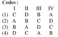
4. Match List-I with List-II and select the correct answer from the codes given below :

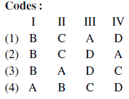
5. Match List-I with List-II and select the correct answer from the codes given below :


6. Lateral planation theory of pediment formation was proposed by
(1) McGee
(2) Gilbert
(3) Lawson
(4) Davis
7. Given below are two statements, one labelled as Assertion (A) and the other labelled as Reason (R). Select your answer from the codes given below :
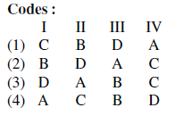
Assertion (A) : Hawaii Island is a region of volcanic activity.
Reason (R) : Convergent plate margins are sites of volcanic eruptions.
Codes :
(1) Both (A) and (R) are correct and (R) is the correct explanation of (A).
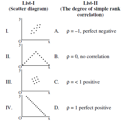
(2) Both (A) and (R) are correct but (R) is not the correct explanation of (A).
(3) (A) is correct, but (R) is false.
(4) (A) is false, but (R) is correct.
8. Which one of the following descriptions is appropriate for the term ‘barotropic’ ?
(1) Isobars and isotherms are parallel.
(2) Isobars and isotherms are not parallel.
(3) Isobars and isohalines are parallel.
(4) Isobars and isohalines are not parallel.
9. Match List-I with List-II and select the correct answer from the codes given below :


10. Match List-I with List-II and select the correct answer from the codes given below :


11. Given below are two statements, one labelled as Assertion (A) and the other labelled as Reason (R). Select your answer from the codes given below :
Assertion (A) : Tropical climates are of special geographical interest.
Reason (R) : Over 75% of the World’s population inhabits between latitudes 30° N and 30° S.
Codes :
(1) Both (A) and (R) are true and (R) is the correct explanation of (A).
(2) Both (A) and (R) are true, but (R) is not the correct explanation of (A).
(3) (A) is true, but (R) is false.
(4) (A) is false, but (R) is true.
12. In Koppen’s classification of climate the symbol Aw refers to
(1) Monsoon climate
(2) Tropical rainforest climate
(3) Steppe climate
(4) Tropical savanna climate
13. Which one of the following is the main energy source for the formation of hurricanes ?
(1) Geothermal energy of the Earth
(2) Latent heat derived from condensed water vapour
(3) Large scale fossil fuel burning
(4) Formation of Ozone (O3) hole
14. Which one of the followings is the correct average air mass density at the surface of the Earth ?
(1) 0.9 kg m–3
(2) 1.2 kg m–3
(3) 1.5 kg m–3
(4) 0.7 kg m–3
15. In which one of the following atmospheric layers the temperature decreases with height at an average rate of about 0.6 °C per 100 m ?
(1) Troposphere
(2) Stratosphere
(3) Thermosphere
(4) Ionosphere
16. Match List-I with List-II and select the correct answer from the codes given below :


17. Which one of the following was first to put forward the concept of ‘life form’ among plants in 1934 ?
(1) A.S. Moffat
(2) R.H. Whittaker
(3) Christen Raunkiaer
(4) E.O. Box
18. Match List-I with List-II and select the correct answer from the codes given below :


19. Match List-I with List-II and select the correct answer from the codes given below :


20. Which one of the following is the correct average slope angle of continental slope ?
(1) 2º
(2) 4º
(3) 6º
(4) 8º
21. Given below are two statements, one labelled as Assertion (A) and the other labelled as Reason (R). Select your answer from the codes given below :
Assertion (A) : Coral reefs tend to be most extensively developed along the eastern edges of continents.
Reason (R) : Sea water is warmer than 20 ºC.
Codes :
(1) Both (A) and (R) are true and (R) is the correct explanation of (A).
(2) Both (A) and (R) are true, but (R) is not the correct explanation of (A).
(3) (A) is true, but (R) is false.
(4) (A) is false, but (R) is true.
22. Which one of the following is the main chemical composition of coral reefs ?
(1) MgCO3 (Magnesium Carbonate)
(2) KCO3 (Potassium Carbonate)
(3) NaCl (Sodium Chloride)
(4) CaCO3 (Calcium Carbonate)
23. The transition zone between two ecosystems is called
(1) Biotope
(2) Ecotone
(3) Biome
(4) Habitat
24. Who wrote the book ‘La Geographie Humaine’ ?
(1) P.E. James
(2) Jeans Brunhes
(3) R.J. Johnston
(4) E. Jones
25. Who amongst the following defined geography as a chorological Science ?
(1) Richthofen
(2) Hettner
(3) Ptolemy
(4) Peter Haggett
26. Match List-I with List-II and select the correct answer from the codes given below :


27. “The dominant idea in all geographical progress is that of terrestrial unity.” This statement is attributed to
(1) Richard Hartshorne
(2) Vidal de la Blache
(3) Jean Brunhes
(4) Friedrich Ratzel
28. Who was the first promoter of geographical knowledge from Germany ?
(1) Ferdinand Von Richthofen
(2) Carl Ritter
(3) Carl Andree
(4) Oscar Peschel
29. Stop and go determinism was postulated by whom ?
(1) Humboldt
(2) Jean Brunhes
(3) Griffith Taylor
(4) Ratzel
30. Match List-I with List-II and select the correct answer from the codes given below :


31. How many stages of population growth are involved in demographic transition ?
(1) 3
(2) 4
(3) 5
(4) 6
32. As per census of India how many categories of urban settlements are identified ?
(1) 3
(2) 4
(3) 5
(4) 6
33. Which one of the following models is based on the study of human ecology ?
(1) Burges and Park’s concentric zone model
(2) Weber’s location model
(3) Haggerstrand’s innovation diffusion model
(4) Zelinsky’s mobility transition model
34. As per the Indian census, the difference of sex ratio (Females per 1000 males) of the total population in India between 2001 and 2011 was
(1) 5
(2) 6
(3) 7
(4) 8
35. Match List-I with List-II and select the correct answer from the codes given below :

36. The census of India (2011) states that maximum density of population is found in which of the following Union Territories ?
(1) Andaman and Nicobar Islands
(2) Lakshdweep Islands
(3) Dadra and Nagar Haveli
(4) Daman and Diu
37. According to census, the literacy rate (%) of India in 2011 was recorded as
(1) 80
(2) 78
(3) 76
(4) 74
38. Which one of the following conditions of Input price variables is applicable in the given diagram of the deviation of a boundary between the market areas of two competing firms A and B, where freight rate is equal ?

Codes :
(1) Ap > Bp
(2) Ap < Bp
(3) Ap = Bp
(4) Ap ≥ Bp
39. The nature of input cost-curve over space in industrial landscape becomes
(1) Convex
(2) Concave
(3) Linear
(4) ‘U’ shaped
40. Among the following authors, who wrote the book entitled ‘Locational Analysis in Human Geography’ ?
(1) P. Haggett
(2) T. Hagerstrand
(3) P. Hall
(4) D. Gregory
41. Given below are two statements, one labelled as Assertion (A) and the other labelled as Reason (R). Select your answer from the codes given below :
Assertion (A) : Urbanization is a defining phenomenon of this century and the developing countries are at the focus of this transformation.
Reason (R) : The urban shift has happened in the last few decades largely due to rapid growth of mega cities in the developing countries.
Codes :
(1) Both (A) and (R) are true and (R) is the correct explanation of (A).
(2) Both (A) and (R) are true, but (R) is not the correct explanation of (A).
(3) (A) is true, but (R) is false.
(4) (A) is false, but (R) is true.
42. Nomothetic approach in geography emphasizes of
(1) Induction study
(2) Ideographic study
(3) Law making study
(4) Empirical study
43. Alfred Weber’s approach to optimization of spatial process in industrial landscape was towards the search of :
(1) Maximum revenue location
(2) Least transport cost location
(3) Uniformity of input demand
(4) Uniformity of plant revenue
44. The major occupation of the people of Mediterranean lands is :
(1) Nomadic herding
(2) Livestock farming
(3) Growing of tropical crops
(4) Growing of grains & fruits
45. Where are Tapovan and Vishnugarh Hydroelectric projects located ?
(1) Uttar Pradesh
(2) Madhya Pradesh
(3) Uttarakhand
(4) Jharkhand
46. Which state in USA grows wheat in spring season ?
(1) North Dakota
(2) Texas
(3) Nebraska
(4) California
47. Who coined the term GEOPOLITICS ?
(1) Spykman
(2) Mackinder
(3) Kjellen
(4) Haushoffer
48. The Tribal Welfare Committee (1952) classified Indian tribes into how many categories ?
(1) 5
(2) 4
(3) 3
(4) 2
49. The Hottentots are the
(1) Negritos of Sri Lanka having brown colour
(2) Yellow skin colour people of South-West Africa
(3) Negritos of East Africa
(4) Pigmies of Cango basin
50. Match List-I with List-II and select the correct answer from the codes given below :


51. Which one of the following authors developed the theory of social physics to create the field of macro geography ?
(1) Stewart and Warntz
(2) Jackson and Smith
(3) Shevky and Bell
(4) Jones and Eyles
52. Who defined cultural geography “which emphasizes human cultures and is commonly equated with human geography” ?
(1) John Eyles
(2) Emrys Jones
(3) Dudley stamp
(4) Eshref Shevky
53. Edward L. Ullman’s 1957 study on commodity flows to study spatial interaction and regional economic structure was based on economy of which country ?
(1) Europe
(2) U.S.A.
(3) U.K.
(4) Australia
54. Match List-I with List-II and select the correct answer from the codes given below :


55. Match List-I with List-II and select the correct answer from the codes given below :


56. Which one of the following is not in conformity with the central place theory ?
(1) Central place is a settlement providing services for the population of its hinterland.
(2) Hierarchy and nesting pettern results in maximum number of central places
(3) Ubiquities and localized raw materials
(4) Market areas for different goods resemble nets of hexagons
57. Match List-I with List-II and select the correct answer from the codes given below :


58. The gravity principle in identification of nodal regions states that the interaction between two geographical points is directly related to their
(1) Distance
(2) Masses
(3) Size of settlement
(4) Mode of transport
59. Which one of the following is located in the Bastar region ?
(1) Dandeli wildlife Sanctuary
(2) Rajaji National Park
(3) Bandhavgarh National Park
(4) Indravati National Park
60. Who among the following formalized the concept that there exists relationship between the spatial organization and national development ?
(1) Kuklinski
(2) Dickens
(3) Friedmann
(4) Luten
61. Who wrote the book “Growth Pole, and Growth Centres for Regional Economic Development in India” ?
(1) Misra, Rao and Sundaram
(2) Sundaram and T.B. Lahiri
(3) Sen and Wanamali
(4) Sadasyuk and Sengupta
62. Match List-I with List-II and select the correct answer from the codes given below :

63. The oldest rocks in India are reported from
(1) Siwalik range
(2) Aravali range
(3) Dharwar region
(4) Vindhyan range
64. Match List-I with List-II and select the correct answer from the codes given below :


65. Given below are two statements, one labelled as Assertion (A) and the other labelled as Reason (R). Select your answer from the codes given below :
Assertion (A) : India is a multi-religious and multi-ethnic society.
Reason (R) : The constitution of India offers to all citizens, individually and collectively, fundamental rights without discrimination on grounds of religion, race, caste, sex or place of birth.
Codes :
(1) Both (A) and (R) are true and (R) is the correct explanation of (A).
(2) Both (A) and (R) are true, but (R) is not the correct explanation of (A).
(3) (A) is true, but (R) is false.
(4) (A) is false, but (R) is true.
66. Select the correct sequence of the Eastward flowing rivers of peninsular India from North to South :
(1) Subarnarekha, Krishna, Mahanadi, Godavari, Cauvery, Vaigai, Pennar
(2) Subarnarekha, Mahanadi, Godavari, Krishna, Pennar, Cauvery, Vaigai
(3) Mahanadi, Godavari, Subarnarekha, Krishna, Cauvery, Vaigai, Pennar
(4) Godavari, Subarnarekha, Krishna, Pennar, Vaigai, Cauvery,Mahanadi
67. Match List-I with List-II and select the correct answer from the codes given below :


68. Which one of the following systems uses the vector and raster data ?
(1) Remote Sensing System
(2) Geographical Information System
(3) Global Positioning System
(4) Both (1) and (2)
69. Which one of the following linear length measures could be derived from the fractional measure of 10–6 metres ?
(1) Nanometre
(2) Micrometre
(3) Millimetre
(4) Femtometre
70. Match List-I with List-II and select the correct answer from the codes given below :


71. In order to study standard of living among the large, medium, small and marginal farmers of a region, which of the sampling technique would be more appropriate ?
(1) Random sampling
(2) Stratified Random sampling
(3) Opportunity sampling
(4) Multistage sampling
72. Which of the following is a non-quantitative areal distribution map ?
(1) Choropleth
(2) Isopleth
(3) Multiple dots
(4) Choroschematic
73. Match List-I with List-II and select the correct answer from the codes given below :

74. Which one of the following equations represents a true mathematical characteristic of mean ?
(1) ![]()
(2) ![]()
(3) ![]()
(4) ![]()
75. Given below are two statements, one labelled as Assertion (A) and the other labelled as Reason (R). Select your answer from the codes given below :
Assertion (A) : Area sampling by random numbers requires the area under study which should be gridded within two areas at right angle.
Reason (R) : The intersections of row and column of the area will give the sample locations of observation in the area.
Codes :
(1) Both (A) and (R) are true and (R) is the correct explanation of (A).
(2) Both (A) and (R) are true, but (R) is not the correct explanation of (A).
(3) (A) is true, but (R) is false.
(4) (A) is false, but (R) is true.
Latest Govt Job & Exam Updates: