| Lok Sabha Constituencies in Ganjam district, Odisha (MP Constituencies) | Aska Berhampur |
| MLA Assembly Constituencies in Ganjam district, Odisha | Aska Berhampur Bhanjanagar Chhatrapur Chikiti Digapahandi Gopalpur Hinjili Kabisuryangar Khalikote Polasara Sanakhemundi Surada |
About Ganjam District :
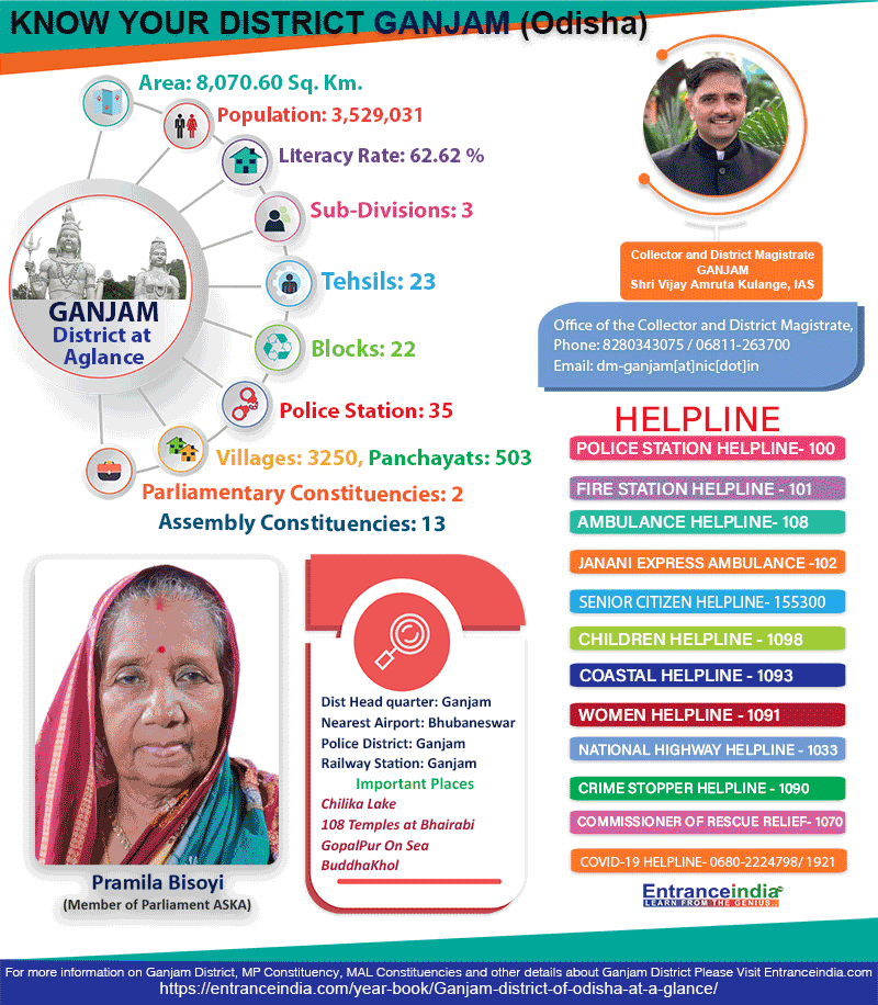
Located on the boarder of Andhra Pradesh, Ganjam District came into existence on 1st April 1936. The district is named after the old township and European fort of Ganjam situated on the northern bank of river Rushikulya which was the head quarter of the District. The Ganjam area was a part of ancient Kalinga which was occupied by Ashok in 261 B.C. The period of 1757 was ruled by the French Commander Bussy. In 1759, the French ruler was defeated by English and the District was annexed by them. The office of the District Collector was established in 1974. The District got separated from the Madras Presidency and formed the part of the newly created State of Odisha province with effect from 1.4.1936.
Ganjam District is on 19.4 to 20.17 degree North Latitude and 84.7 to 85.12 degree East Longitude. It covers an area of 8070.60 sq km. The district is braodly divided into two divisions, the Coastal plain area in the east and hill and table lands in the west. The eastern ghats run along the western side of the District. The climate of Ganjam is characterized by an equable temperature round the year, particularly in the coastal regions. The District‘s cold season from December to February is followed by hot season from March to May. The District experiences normal annual rainfall of 1444 mms.
Agriculture is a traditional occupation and the way of living of the inhabitants of the Ganjam District. The District is well known for its fertile soil and agricultural productivity. A large variety of crops are grown here like Paddy, Ground nut, Sugar cane, Oil seeds, Ragi, Mung, Biri etc. Because of the agro climatic condition Ganjam is included as the agricultural District.
The literacy rate of the ganjam district is above 60 percent. There are many reputed educational institutes in the District like Brahmapur University, Ganjam Law college, Lingaraj Law college, NIST, Khalikote College Brahmapur, R.C.M. Science college Khalikote, Government Science College Chhatrapur, Maharaja Krushna Chandra Gajapati Medical College, Nursing College, and Pharmaceutical Colleges etc.
Ganjam District celebrates many festivals round the year. Dola Yatra, Tara Tarini Mela, Thakurani Yatra, Durga Puja, Shiv Ratri, Ratha Yatra, Makar Sankranti, Manabasa Gurubara and Danda Yatra are the famous festivals being celebrated in the District with great enthusiasm. Ganjam District is full of many tourist spots that are visited by a large number of tourists every year like Arjyapalli, Athagadapatna, Balkumari, Brahmapur, Bhairabi (Mantridi), Bhetanai, Biranchi Narayan, Budhakhol- Buguda, Chilika (Rambha), Girisola, Gopalpur sea beach, Taratarini etc
Ganjam District is the land of many prominent personalities like: Bharat Ratna Varahgiri Venkat Giri, Biswanath Dash, Binayak Acharya, Kabi Samrat Upendra Bhanja, Sasi Bhusan Rath, Kabi Surjya Baladeba Rath, Kalinga Bira Biju Pattnaik, Raja Bahadur Ramachandra Mardaraj Deo, Chakara Bisoyi, Padmasri Bhagaban Sahu.
District at a Glance :
|
|||||||||||||||||||||||||||||||||||||||||||||||||||||||||||||||||||||||||||||||||||||||
| Administrative Setup : | |||||||||||||||||||||||||||||||||||||||||||||||||||||||||||||||||||||||||||||||||||||||
|
|||||||||||||||||||||||||||||||||||||||||||||||||||||||||||||||||||||||||||||||||||||||
Tourist Places :
Bhairabi :

The place is named after the presiding deity Goddess Bhairabi at remote village Mantridi. Bhairabi now a days has become an important Shakti Pitha. Tourists from all most all parts of Odisha as well as northern Andhra Pradesh visit this holy shrine everyday.
Gopalpur-on-Sea :

Melancholy and Salubrious Sea beach with blue waters and attractive back water bed in the form of cracks and sleepy lagoon covered with canopies of lush green foliage. The remnants of a vanishing British made port buildings speak the golden days of Southern Odisha from where ships were sadling to Rangoon.
Taptapani :

It is famous for a perennial hot spring of Medicinal Sulfuric Water which is located on the State Highways that connects Berhampur with Western Odisha. Being surrounded by a cluster of hills and thick forests, the serenity of nature at Taptapani is added by wonderful sights of sun rise, sun set moon lit night, tribal dance and music, chirps of birds and sight of wild animals. The place as such attracts large numbers of tourists of all category. Poets, writers, scholars, picnickers, holiday makers and newly weds can best exploit the place through all seasons
Latest Govt Job & Exam Updates: